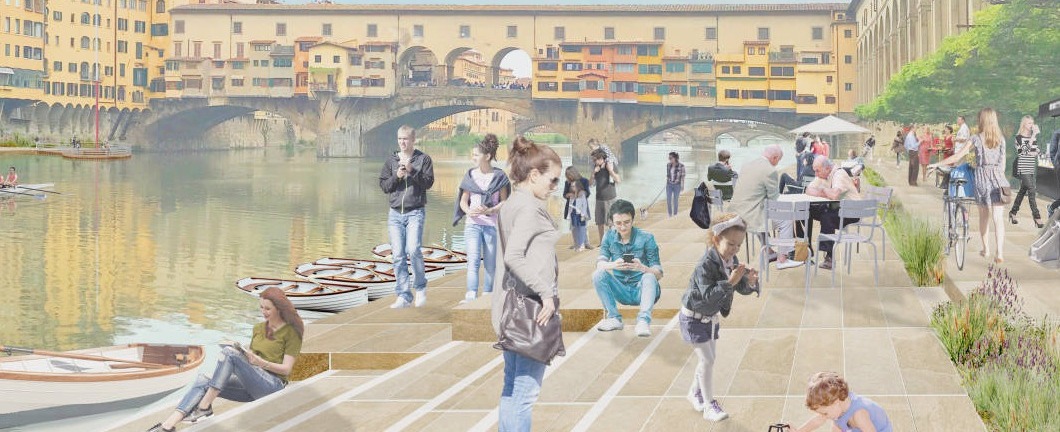
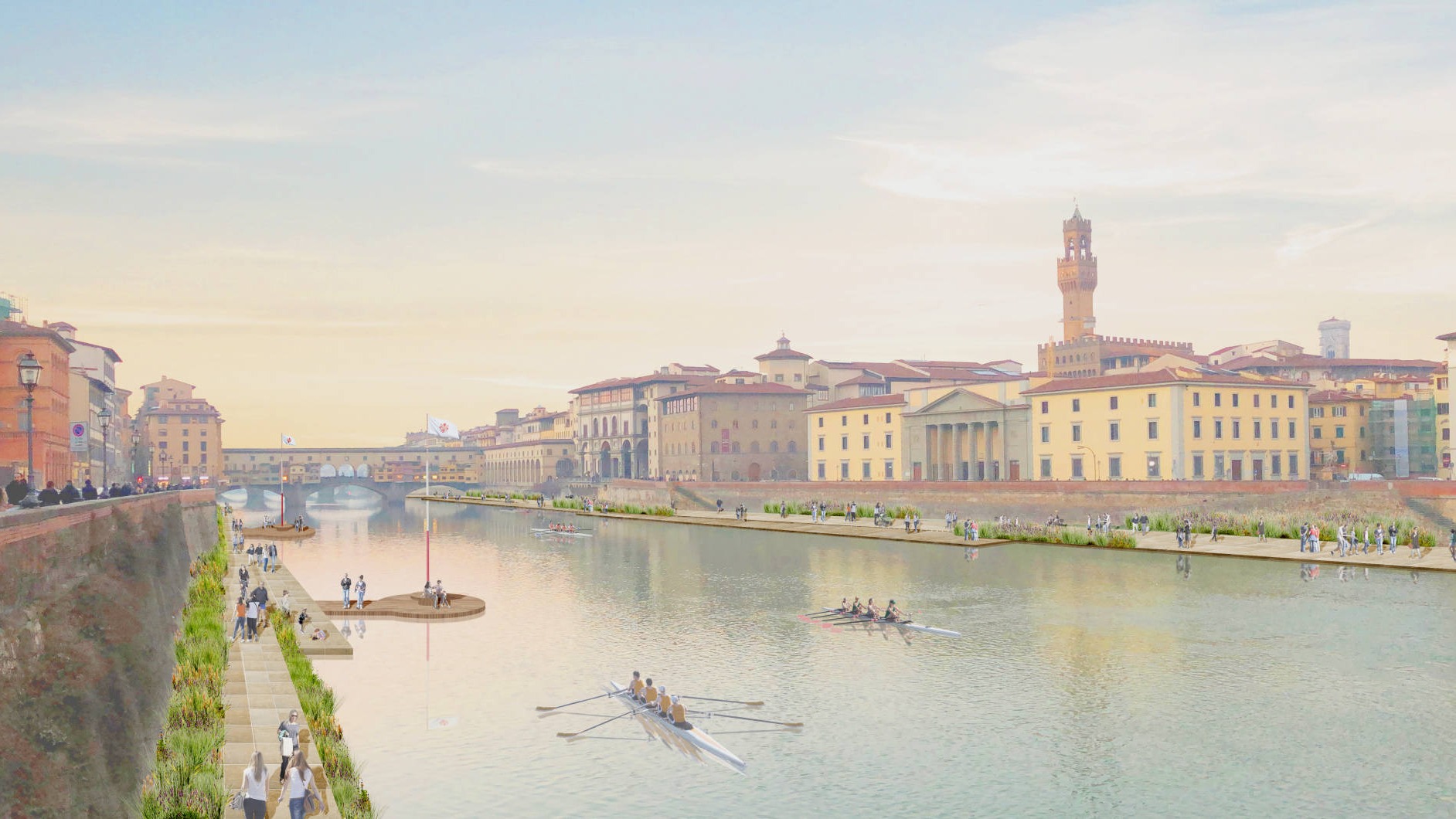
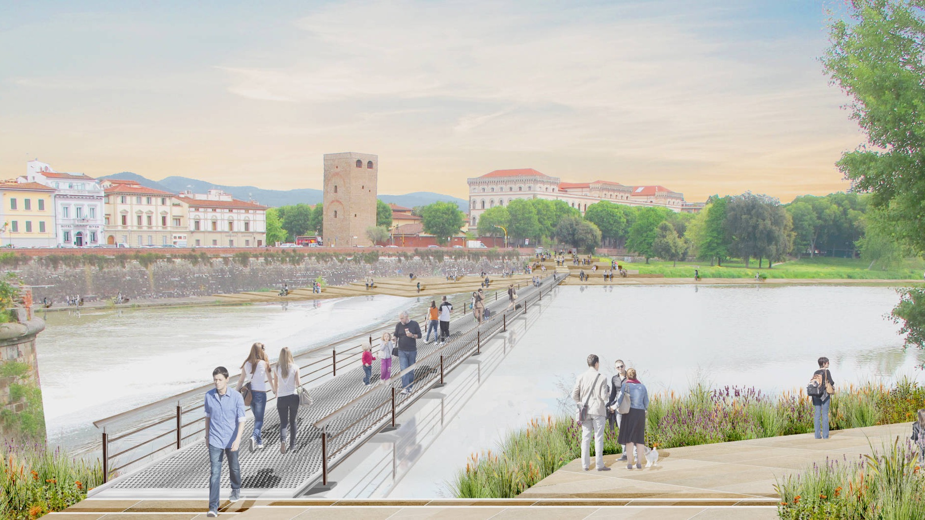
Il fiume Arno - in origine linfa vitale di Firenze - per molti anni è stato dimenticato dalla città diventando sempre più inaccessibile e al contempo elemento di separazione fisica e visiva tra le due sponde. La paura per le alluvioni ha provocato l’innalzamento delle spallette e i Lungarni sono diventati sempre più congestionati da auto e pedoni. L’ambizione di questo progetto è di recuperare il rapporto tra città e fiume attraverso una serie di interventi di riqualificazione urbana lungo l’intero asse fluviale da Est a Ovest. Le opere di regimentazione idraulica eseguite negli anni passati consentono una maggior sicurezza e permettono finalmente ai cittadini di frequentare le sponde del fiume. Il fiume Arno rappresenta una delle più importanti risorse naturali per Firenze e come tale deve essere salvaguardato e dove necessario riqualificato. Ristabilire una familiarità tra fiume e cittadino e aumentare la conoscenza del suo ecosistema possono contribuire a rendere il fiume più rispettato, meno inquinato e di conseguenza maggiormente frequentato e facilmente accessibile. La nostra proposta originale del 1983 individua una soluzione radicale per trasformare l’Arno in un parco lineare pubblico. Un luogo accessibile dai cittadini per riconnettere la città. Molte delle proposte contenute in quel progetto sono ancora attuali forse oggi ancor di più. Firenze è una città di grande storia e come tale ha l’onore e l’onere di mostrare i suoi beni culturali al mondo. Il numero di turisti continua ad aumentare ed ha raggiunto ormai 36 milioni di visitatori all’anno. È necessario implementare una strategia per consentire alla città di svilupparsi in modo equilibrato e sostenibile che garantisca qualità della vita ai suoi cittadini e allo stesso tempo sia capace di accogliere i turisti da tutto il mondo. Gli sforzi compiuti per valorizzare il centro e i suoi beni culturali devono ora concentrarsi sulla riqualificazione dell’intero sistema urbano che comprenda una decentralizzazione delle attività e un sistema di connessioni tra centro e periferia che aiuti a decongestionare le zone centrali e a riqualificare le aree periferiche. In questo senso molti interventi sono stati realizzati all’interno della città negli ultimi anni. Il più importante tra tutti è stata la realizzazione della rete tramviaria che ha creato un sistema di connessione tra tutti i principali nodi urbani con il centro storico, una rete di trasporto pubblico dinamica, sostenibile e facilmente accessibile. L’attuale proposta quindi si fonda e amplia ulteriormente la visione originale del 1983 alla luce dei nuovi interventi e trasformazioni della città. La riqualificazione dell’asse del Fiume consente di creare un importante asse Est-Ovest di connessione pedonale tra il centro e le aree più periferiche della città e favorisce, lungo tale asse, interventi di riqualificazione urbana ben connessi al centro storico. L’intero progetto potrà portare a Firenze nuovi spazi pubblici e riqualificare le aree su entrambe i lati del fiume. Ad Ovest della città, la proposta di un nuovo parco e un polo universitario, incentrati sul tema dei cambiamenti climatici e dell’acqua, creeranno una destinazione al termine del nuovo parco lineare. Collegato con tram, ponti e passerelle, questo nuovo polo sarà fortemente collegato al centro storico della città nonché al quartiere delle Piagge e ai quartieri circostanti oltreché al Parco delle Cascine e all’Isolotto. Un’opportunità per decongestionare il centro storico e per contribuire alla riqualificazione delle aree periferiche. Ad Est la riqualificazione delle sponde e l’estensione della rete dei percorsi pedonali e ciclabili lungo il fiume consentiranno di collegare il centro con il Parco dell’Albereta fino alla Nave connettendo S. Niccolò, i giardini del Lungarno del tempio, i giardini di Bellariva e la zona di Gavinana. Nei pressi del Lungarno della Zecca Vecchia si prevede di creare una ‘porta di accesso’ verso il centro storico della città per accogliere i visitatori. A differenza dell’attuale sistemazione in cui i turisti vengono incanalati lungo la riva nord, saranno disponibili diverse direttrici di accesso alla città. La principale sarà attraverso una nuova passerella pedonale che collega la sponda Nord con la Porta S. Niccolò. Su entrambe i lati del fiume si propone di creare una passeggiata pedonale al livello del fiume. Ciò non solo aiuterà ad alleviare la congestione a livello stradale, ma ristabilirà anche alcune viste storiche della città dal fiume, che da lungo tempo sono state dimenticate. Strutture per il canottaggio, la navigazione e il tempo libero animeranno i percorsi pedonali e creeranno dei luoghi di attrazione. Le nuove passeggiate fluviali si svolgeranno attraverso il tratto centrale del fiume con accesso attraverso una serie di punti di discesa al fiume e si connetteranno ai percorsi esistenti delle Cascine e dell’Isolotto ad Ovest, e dell’Anconella e dei Giardini di Bella Riva ad Est. Essenziale per la proposta è che la sezione idraulica del fiume rimanga invariata. Pertanto, le zone pavimentate verranno implementate laddove esiste una sponda. Dove non esistono sponde si potranno prevedere installazioni mobili temporanee, facilmente smontabili e in grado di essere rimosse in caso di piena. Queste passerelle saranno stagionali, pensate e progettate appositamente per il microclima e il contesto di Firenze. Molti di questi percorsi scompariranno sott’acqua quando il livello del fiume salirà nei mesi invernali, per riapparire la primavera successiva all’inizio della nuova stagione.
The Arno river - originally the lifeblood of Florence - for many years has turned its back on the city, becoming increasingly inaccessible and at the same time an element of physical and visual separation between the two shores. The fear of floods has caused the raising of the parapets and the Lungarni have become increasingly congested with cars and pedestrians. The ambition of this project is to recover the relationship between the city and the river through a series of urban redevelopment interventions along the entire river axis from East to West. The hydraulic regeneration works carried out in past years allow greater safety and finally make it possible to bring citizens back to the river banks. The Arno River represents one of the most important natural resources for Florence and as such must be safeguarded and redeveloped where appropriate. Restoring a familiarity between the river and the citizen and raising the awareness of its ecosystem can contribute to making the river more respected, less polluted and consequently more frequented and easily accessible. Our original 1983 proposal identifies a radical solution to transform the Arno into a public linear park. A place accessible by citizens to reconnect the city. Many of the proposals contained in that project are still current today, and perhaps even more so. Florence is a city of great history and as such has the honor and the burden of showing its cultural heritage to the world. The number of tourists continues to increase and has now reached 36 million visitors a year. It is necessary to implement a strategy to allow the city to develop in a balanced and sustainable way that guarantees quality of life to its citizens and at the same time is able to welcome tourists from all over the world. The efforts made to enhance the center and its cultural heritage must now focus on the redevelopment of the entire urban system which includes a decentralization of activities and a system of connections between the center and the periphery that helps regenerate the peripheral areas and relieve congestion in the central areas. In this sense, many interventions have been carried out within the city in recent years. The most important of all is the construction of the tram network which created a connection system between all the main urban nodes with the historic center, a dynamic, sustainable and easily accessible public transport network. The current proposal is therefore based on and further expands the original vision of 1983 in light of the new interventions and transformations of the city. The redevelopment of the axis of the River allows the creation of an important East-West pedestrian connection between the center and the most peripheral areas of the city and favors, along this axis, urban redevelopment projects well connected to the historic center. The entire project will bring new public spaces to Florence and redevelop areas on both sides of the river. To the west of the city, the proposal of a new park and a university centre, focused on the theme of climate change and water, will create a destination at the end of the new linear park. Connected with trams, bridges and walkways, this new centre will be strongly connected to the historic centre of the city as well as the Piagge district and surrounding neighborhoods as well as to the Parco delle Cascine and the Isolotto. An opportunity to decongest the historic centre and to contribute to the redevelopment of the peripheral areas. To the east, the redevelopment of the banks and the extension of the network of pedestrian and cycle paths along the river will allow the center to be connected with the Albereta Park up to the ‘Nave’ connecting S. Niccolò, the gardens of the Lungarno del Tempio, the gardens of Bellariva and the area of Gavinana. Near the Lungarno della Zecca Vecchia it is planned to create a “gateway” to the historic centre of the city to welcome visitors. Unlike the current accommodation in which tourists are channelled along the north shore, there will be several access routes to the city. The main one will be through a new pedestrian walkway that connects the northern shore with the Porta S. Niccolò ‘. From here in turn you can access the Ramps (recently restored) and Piazzale Michelangelo or the Third Garden and the Lungarno Serristori thus creating a new pedestrian access axis to the city on the left bank. On both sides of the river it is proposed to create a pedestrian walkway at river level. This will not only help alleviate congestion at street level, but will also restore some historical views of the city from the river, which have long been forgotten. Rowing, navigation and leisure facilities will animate the pedestrian paths and create places of attraction. The new river walks will take place through the central stretch of the river with access through a series of descent points to the river and will connect to the existing paths of the Cascine and the Isolotto to the West, and of the Anconella and the Gardens of Bella Riva to the East . Essential for the proposal is that the hydraulic section of the river remains unchanged. Therefore, the paved areas will be implemented where there is a bank. Where there are no banks, temporary mobile installations can be provided, which can be easily dismantled and can be removed in the event of flooding. These walkways will be seasonal, designed and designed specifically for the microclimate and the context of Florence. Many of these paths will disappear underwater when the river level rises in the winter months, to reappear the following spring at the beginning of the new season.
RSH+P

Drag and Drop Website Builder